


SPECTATOR'S LIBRARY.
Law or NATIONS.
The Oregon Question Examined in reaped to Facts and the Law of Nations. By Travers Twiss, D.C.L., F.R.S., Professor of Political Economy In the rniverslty of
Oxford, and Advocate tit Doctors' Commons Longman node*.
VolAcain AND THANXIS, Trade and Travel in the Far East ; or RecollecUons of Twenty-one Tears passed in Java, Singapore, Australia, and China. By G. F. Davidson. Madden and Makoam.
DR. TWTSS's OREGON QIIESTrell EXAMINED.
Aurnoncii appearing late in the controversy, Dr. Twin's Oregon Question Examined cannot be considered late in the day, since we are now arrived at a point when the dispute should be finally settled. While the negotiations—as in 1818, 1823-24, and 1826-7—were confined to diplomatists, and only appeared after the result in cumbrous blue books and similar receptacles, the world at large might be justified in leaving the matter to the " politicals." After the late appeals of the President of the United States to legislative and popular passions prejudices, and ignorance, and the influx of American settlers into Oregon, the matter is one in which the public of this country- should take some trouble to master the rights of the case, since to none is it of so much concern. Upon the publievoice of this country really depends the question of peace or war. If it decide weakly for peace at any price, it is likely to provoke further encroachments, and may be driven at last into hostilities merely to show that it is "not afraid," with a worse cause, and under more un- favourable circumstances as to preparation. If it decide rashly for war, it will be involved in a conflict of which no man can foresee the end ; for the nominal object of dispute may be seized at once, and hostilities will take place anywhere and everywhere but in Oregon. Unless England should be driven out of the whole of her American possessions, or the old States on the Atlantic break up the Union in an early stage of the war, it will be, in the words of Guicciardini, one "of those undertakings and affairs which are not to be expected to Dill through by any sudden shock, but through consuming and wasting away," and which "draw out to a much greater length than is believed at first."
77w Oregon Question Examined of Dr. Tulsa is exceedingly weN adapted to enable the reader to form a just opinion upon the subject; possibly better than any other publication, or even than the original docu- ments. Not only are the diplomatic points at issue embraced in the book, but collateral subjects are handled with the learning of the civilian and the accomplishments of a rare scholarship—which in the instance of the latitude reached by-Drake throws a flood of light upon a point to which . the American view at least attaches no small importance, and which his- torically is of weight. Here and there a little of the heaviness and for- mality of the civilian may be met with, and the method of treatment in- volves occasional repetitions ; but the book will be found readable, in- teresting, and complete; embracing all the main diplomatic points, tested by the laws of nations, and all the geography and history of the subject, illustrated by a various and peculiar learning, which the circumstances and "go-ahead" habits of America prevent her citizens from attaining.
In his arrangement Dr. Twigs is exhaustive, and chronological so far as it is practicable. He commences with a description of Oregon, and of the various reports respecting its interior - which had not been pene- trated, much less explored, till the last decade of the eighteenth century. He next gives a history of the discoveries along the North-west coast of America, or rather of the voyages ; and pursues the same plan with the land expeditions and trading settlements, sometimes noting their larger bearing upon the subject, but more generally confining himself to the geographical and literary questions. The seizure of the British vase's by the Spaniards at Nootka Sound (1789) and the convention of the Escurial (1790) follow the discoveries ; except that the subject of the Columbia river comes after the Nootka Sound business, as it followed in the order of time. Several chapters on national law respecting the acquisition of territory follow : then we have a discussion on the limits of the province of Louisiana, (which Mr. Falconer, however, had exhausted,) and an account of the different negotiations that have taken place in re- ference to the Oregon question between the Government of Washington and the Courts of London and Madrid: lastly; a review of the whole question, and a proposal of Dr. Twiss to modi6- our demand.
A very clear and close account of the principles of national law as they bear upon the subject at issue and a very succinct though quiet exposure of the extreme arguments and shifting artifices of the American diplo- matists, will be found in the volume ; but the best single part of it is the argument on Drake's voyage. The question (so far as it can be now de- termined) as to whether Drake reached latitude 430, or 48°, rests upon the respective credit to be assigned to an account in Hakluyt, which limits Drake's advance to 430, or to "The World Encompassed," which fixes 480. The authority of each will of course rest upon the probable writer, the materials he had access to, and his own means of personal knowledge. The evidence, as it turns out, rests almost solely upon literary and indeed bibliographical knowledge, often of a minute kind—es the collation of signatures, and paging of an edition, to test whether the insertion of a par- ticular narrative has not been an afterthought—and a very extensive ac- quaintance with the geographical publications of the age. The exposition of Mr. Greenbow's errors by Dr. Twigs is of a most masterly kind, if he does not absolutely establish the certainty of Drake's having reached 480. It is as clear, as thorough, and as attractive, as Bolton Corney's exposures of D'Iameli the Elder, but without any of the mockery with which Mr. Corney treated those "Curiosities of Literature "; for Dr. Tulsa is polite to an extreme. It is true that Mr. Greenhow is not to blame for his want of bibliographical or minute historico-geographical knowledge, wince the mind of his nation is indisposed to such studies, and the means do not exist to pursue them, from the want of rare books in American public libraries. But Mr. Greenhow was wrong to assert that "The World En- compassed" was not published till 1652, when that edition was the third, the first having appeared in 1628, and the second in 1635,—especially
"as Watts, in his Bibliotheca Britannica, refers to the first edition, of 1628." It would seem, too, that he was still more wrong to declare that he did not "cite authorities at second-hand"; for Dr. Twiss's elaborate
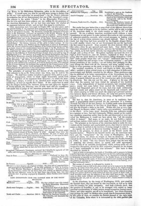
investigation has all but demonstrated that one of Mr. Greenhow's recon- dite sources is the article "Drake" in the Biographie Universelle. Nor let it be said that these subjects are too trifling for the greatness of the American diplomatists; for see how they seize upon the shadow of an argument however trivial ; and see how they jump to conclusions. "Some observations have been made in Chapter XII. and other places upon the general futility of the argument from maps in the case of disputed territory-. The late negotiations at Washington have furnished an apposite illustration of the truth of the author's remarks. Mr. Buchanan, towards the conclusion of his last letter to Mr. Pakenham, addressed an argument to the British Minister, of the kind known to logicians as the argumentum ad verecundiam. Even British geographers have not doubted our title to the territory in dispute. There is a large and splendid globe now in the Department of the State, recently received from London, and published by Maltby and Co , manufacturers and publishers to the Society for the Diffusion of Useful Knowlenge, which assigns this territory to the United States.' The history, however, of this globe is rather curious. It was ordered of Mr. Malby (not Maltby) for the Department of State at Washington, before Mr. Everett quitted his post of Minister of the United States in this country. It no doubt deserves the commendation bestowed upon it by Mr. Buchanan, for Mr. Malby manufactures excellent globes; but the globe sent to Washington was not made from the plates used on the globes published under the sanction of the Society for the Diffusion of Useful Knowledge, though this is not said by way of disparagement to it. The Society, in its maps, has carried the boundary-line West of the Rocky Mountains, along the 49th parallel to the Columbia River, and thence along that river to the sea; but in its globes the line is not marked beyond the Rocky Mountains. Mr. Malby, knowing that the globe ordered of him was in- tended for the Department of State at Washington, was led to suppose that it would be more satisfactorily completed, as it was an American order, it he coloured in, for it is not engraved, the boundary-line proposed by the Commissioners of the United States. The author would apologize for discussing so trifling a circum- stance, had not the authorities of the United States considered the fact of sufficient importance to ground a serious argument upon it." The principles of national law, the history of the negotiations, and their minutiae so far as Dr. Twiss enters into them, may be read in his volume. We shall here confine ourselves to general views, and to a pro- posal of arrangement, which we think might honourably satisfy both parties. And first of the argument from discovery ; to which the Ame- ricans have always, it seems to us, attached more weight than it was entitled to, at least as regards their claims. If the reader bear in mind that the Oregon territory lies between forty-two and fifty-one degrees of North latitude, the following view of both land and sea expeditions will enable him to judge of the American pretensions on this ground.
SEA. VOYAGES ALONG THE COAST,
Navigator's Name. Flag. Date. Latitude reached.
Ulloa Spanish 1539 300.
Cabrillo 1542 37° 10'.
-Ferrelo (Cabriflo's "pilot") „ 1543 40° 20' or 43°. Drake English 1579 43° or 48°. [Dr. Twiss shows there is little doubt bat that 48° is the true point.]
De Gualle Spanish 1584 3711° or 54°. [The 57i is an alteration of a translator; the original account is 87i, in words, not figures.]
Viscaino .Spanish . 1596 42°
D'Agnilar tf 1596 43°.
Perez 1774 550.
Heceta If 1775 49° 30'.
[Inferred the existence of the Columbia from the general appearance of the embouchere or bay.]
De La Bodega Spanish 1775 580.
[These last three voyages were kept secret by the Spanish Govern- ment; and any claims from them lost, as not being proclaimed.] Cook English 1778 44° beyond 60°. [Exact discovery scarcely began till Cook.]
Commercial Expedition ...Russian 1783 600. [Planned from information obtained from King, Cook's successor. It started from the North, proceeding no lower than 60°.]
Various commercial enterprises, chiefly English, now took place, which ended in the Spanish seizure at Nootka Sound in 1789. Amongst these were the well-known names of Dixon, Portlock, and Meares; the last of whom may fairly stand next to Cook and Vancouver as a discoverer, if not equal to them, in the immediate region North of the Columbia. Vancouver English 1792 Surveyed the coast. [Inferred the existence of the Columbia from the river-coloured water.]
Gray American merchant 1792 Entered the Columbia. Baker English merchant...1792 Entered the Columbia. [Appears to have preceded Gray, as Broughton found Baker there; and he stated that he had also been there in the earlier part of the year.]
-Broughton, Vancouver's Lieutenant, surveyed the Columbia for upwards of 100 miles, and took possession, with the consent of the Indians.
The two following are romances.
Juan de Fuca Spanish 1592 Professed to have dis- covered the North-west passage, by sailing through the Continent of North America.
De Fuentes Spanish 1640 770 The last is a mere forgery—no original existing; the story full of improbabilities and geographical impossibilities. It was first published in 1708, at London, in "The Monthly Miscellany, or Memoirs of the Curious." Fuentes is given up by Greenhow : neither he nor Fuca were ever noticed by Spanish writers; and the real difference seems to be, that Fuca was a living man, who lied with the view of getting employed by Elizabeth, whilst Fuentes never existed at all.
LAND EXPEDITIONS FROM THE EASTERN SIDE OF THE ROCKY MOUNTAINS.
Name of 'Traveller. Fla. Date.
'Mackenzie English... 1793. The first civilized man who crossed the Rocky Mountains. Discovered Frazer's River.
.North-west Company English... 1806. First Settlement West of the Rocky Mountains, in 54°,speedily follow- ed by other settlements among the head waters of the Columbia.
Lewis and Clarke American 1805-6. Explored the Southern branches of
the Columbia, and descended the main stream.
Name of 1 ravelle, 11a4 Date.
Missouri Fur Company American 1808. Established a post on the Southern arm of the Columbia.
Astor'a Company American 1811. Established Astoria, at the Southern mouth of the Columbia, which was subsequently sold to the North- west Company. Thomson, North-west Co English... 1811. Descended the Northern branch of
the Columbia and main stream to the mouth, and established a post.
The reader has now before him a coup d'reil of the different discoveries along the coast of Oregon, or in the interior ; and he will be able to judge of the American claim to the whole country as high as 51° on this ground. By sea, a solitary American merchant-vessel, without a state commission, or any power to make national discoveries or take possession of unknown countries, succeeds, after several attempts, in beating over the bar of a river whose existence was already inferred. There is little doubt but that Gray had been preceded by the English skipper Baker, in a still smaller vessel ; but as our Government has not his log-book, the fact cannot be proved. Gray ascended the river between thirty and fifty miles ; when he got aground and came back. Very shortly after, Vancouver returned to the embouchure, and sent his Lieutenant over the bar ; which, as he had rightly inferred, was impassible for his own vessel, though only a sloop of war. Broughton regularly surveyed the river as high as Fort Vancouver; met the Indians ; explained to them his pur- poses, after the usual fashion in which nations calling themselves "civil- ized" make peoples whom they call "savage" understand that they are about to subject the said savages to the "dominium eminens " ; and took formal possession of the country,—an old Indian chief pledging his Ma- jesty George the Third with all the honours, and being equally ready to drink to every potentate on the earth, or below it, in as flowing a cup.
The overland expedition of Lewis and Clarke, in 1805, was another affair ; entitled to great critical praise as a bold conception of Jefferson's, perseveringly and skilfully executed by his officers. These gentlemen may also be admitted to be better representatives of the Government than the skipper Gray ; and any discoveries they made would give America a claim, if properly followed up, and if the country was open to claimants by discovery. But this was not the case. A glance at the map will show that the country bad been visited for upwards of two hundred years. Cook, independently of Spanish navigators, had examined many parts ; nearly ten years before Gray entered the Columbia, British traders had frequented parts of the coast, had even made settlements, had their vessels and places seized by the Spaniards and restored ; and the whole country in 1790 was made the subject of a formal conven- tion between Spain and Great Britain, the only two powers having any claim at that time either from discovery, occupation, or conve- nience.
The fact is, that the Americans' in error or in sophistry, have made a geographical merit a ground for the possession of a country. Towards the close of the last century, Le Vaillant made some discoveries beyond the Dutch territory of the Cape of Good Hope ; but this would not give the French a claim to the land. Within this year or two, Cap- tain Keppel, in Borneo, sailed "eighty miles over mountains" according to the chart. A few years since, Australia Felix was unknown except to a squatter or two ; but had Commander Wilkes started on his explor- ing expedition somewhat earlier than he did, and discovered or even sur- veyed the Melbourne, it would not have given him "all the country which it drained." Bad maps, or no maps, do not forfeit a region ; and perhaps nations which cannot make maps have a right to their coun- try. The principle at the bottom of the American claim is really the con- venient one for insatiate and unprincipled power, that whoever corrects or makes a chart is entitled to the territory, if strong enough to seize it.
As regards the merit of discovery touching Oregon, we believe the British is the greatest, by about as much as the British excels the Spanish marine. Whatever the Spanish merits are, the Americans may have got the "assignment" by the treaty of Washington ; but as matter of claim, we attach no weight to that by discovery. It was waived by the convention of the Escurial, (also called the Nootka Sound,) in 1790; in which "the two Crowns have judged that the best way of attaining this salutary object, [a speedy and solid agreement,) would be that of an amicable arrangement, which, setting aside all re- trospective discussion, should fix their respective situation for the future on a basis conformable to their true interests." This basis is thus described by Article 3.
"And, in order to strengthen the bonds of friendship, and to preserve in future a perfect harmony and good understanding between the two contracting parties, it is agreed that their respective subjects shall not be disturbed or molested, either in navigating or carrying on their fisheries in the Pacific Ocean, or in the South Seas, or in landing on the coasts of those seas in places not already occupied, for the purpose of carrying on their commerce with the natives of the country, or o making settlements there."
The extent of country is indicated in Article 5.
"It is agreed, that as well in the places which are to be restored to the British subjects, by virtue of the first article, as in all other parts of the North-western coasts of North America, or of the islands adjacent, situated to the North of the parts of the said coast already occupied by Spain, wherever the subjects of either of the two powers shall have made settlements since the month of April 1789, or shall hereafter make any, the subjects of the other shall have access, and shall carry on their trade without any disturbance or molestation." [The Spanish settlements did not, and do not now, extend to 40'; Nootka Sound is nearly in latitude 500.]
As the Americans, by the treaty of Washington, 1819, now stand in the Spanish shoes, they are bound by this convention, as well as by their own two treaties, for joint occupancy. And both evidently show, that the question of boundary is one to be arranged with regard to many practical considerations, of which nature, actual occupation, mutual conve- nience, and other matters, are all to be considered; but where discovery may perhaps be used "to thicken other proofs that do demonstrate thinly.' In this point of view, we consider the British demand of the right bank of the Columbia, from where it is intersected by the 49th parallel (the boundary-line of Canada, and which the Americans have all along pro- posed to continue to the Pacific) to fulfil every condition. The line is well-defined, and separates the territory by a water-channel : it gives to either party a means of navigable conveyance, such as it is : although the British have settlers on the Southern side of the Columbia, the Americans, we believe, have none on the North ; which circumstance gives us a clear title by occupation ; and, if geographical discovery has anything to do with the matter, that merit, as was long since urged by the British nego- tiators, is clearly joint and progressive. Heceta—Vancouver—Gray or Baker—Broughton—Clarke and Lewis—Thomson—all helped in discover- ing the river; and it happens that whilst American citizens explored the Southern branches of the Columbia, the Northern branch was de- scended by British subjects,—each party, in fact, starting naturally from their own side.
But although we entertain no doubt about our "rights," or the jus- tice or fairness of the case, the fruitless negotiations of nearly thirty years, the peaceful declarations of Lord John Russell and Sir Robert Peel, as well as the offers that have been officially proposed, show that some modifications must be made, if we do not intend to go to war, or be kept in endless apprehension of it. Dr. Twiss proposes to "declare the ports in Admiralty Inlet and Puget's Sound to be free ports, with a given radius of free territory." This seems open to several objections. In the first place, America has refused a tantamount proposition. In the second place, free ports and free territory—a sort of imperium in imperio, or no-government—are likely to give rise to interminable disputes. What is still more important, the proposal does not save the honour of either party, (which must be guarded as nicely as in "the duello,") for it does not introduce a new principle of settlement, by whose adoption the old one may be got rid of and with it the old demands. Can any such prin- ciple be found ? We think there can ; giving a natural frontier, and upon grounds to which, we presume, an American cannot object. To see the exact nature of our proposition, the excellent map of Oregon which Dr. Twiss has prefixed to his volume would be necessary; but its general character may be conveyed by description.
It must be borne in mind, that the practical point in dispute is the territory between the Columbia river and the 49th parallel ; and the American argument in favour of their demand for this region is that they are entitled by the discovery of the river to the whole valley of the Co- lumbia, including all its tributaries ; "because those who discover a river are entitled TO ALL the country that it drains" ! We have shown the monstrous character of this argument ; but let that pass. If the reader could examine the map, he would see that a considerable, and for British objects not the least valuable portion of the territory in dispute, is NOT drained by the Columbia : and this portion (respect- ing our claim to which there cannot be a doubt) admits of nearly as well-defined a natural boundary, as the Columbia itself. Let therefore both parties agree to leave the Northern territory drained bj the Columbia as a neutral ground, open as the whole of Oregon now is, to settlers of each nation, with a free navigation of the Columbia for a term of years, or to the Hudson's Bay Company daring its existence ;fixing. the American boundary South of the Columbia, and letting the British begin where the Northern tributaries of the Columbia rise. In the upper part of the country, the line we propose is clearly defined by a range of mountains, which distinctly separates the two vallies ; but as this range approaches the longitudinal parallel of the mouth of the Frazer, it sweeps away towards the South at right angles, till it reaches the Columbia above Fort Vancouver. A na- tural boundary, however, may still be found; for the Cowlitz is the only, at all events the largest river falling into the Columbia between this range and the sea. Let, therefore, the sources of the Cowlitz be the British boundary North of the Columbia ; or rather, the main branch of the Chickeelea river, (which falls into Gray's Harbour near latitude 47°,) with a direct line thence to Mount Rainier. From Mount Rainier the mountains themselves will mark the division, till the 49th parallel is struck, when any line will suffice to the Rocky Mountains. For the whole of these uplands, so far as they are known, are bleak, barren, and worthless ; and were the country peopled as densely as France, they would be of no more value than the uplands of the Alps or the Pyrenees. Thus, the British would take all the country drained by Frazer's River and the inlets and straits of Vancouver's Island; the Americans, every- thing South of the Columbia ; the Northern territory of the Columbia being left neutral. Or, when the boundaries are settled, this district might be submitted to arbitration, on the single question—" Who is to have it ? "
By acting upon this proposal, the point of honour is saved to both dis- putants. It must, however, be avowed, that the substantial concession and loss are all on the side of Great Britain. We e,ertainly give up fair claims—in our opinion, undoubted rights—to the Northern confines of the Columbia ; and if the region be left open to both nations, it will event- ually become American by mere influx of numbers. Mr. Calhoun's view is quite correct, that time will quietly give the United States the territory under treaties of joint occupation. This cannot be helped. The par- ties start on equal terms, but it is in the nature of things that America Should win. National circumstances make the Americans much more Moveable than the English; and Oregon is practically nearer—stands in Closer relation to the United States—than even Lower Canada does to England. People may regret this result ; but to act with the hopes of flanging it, were as idle as to try to alter the longitude of New York. It must also be borne in mind, that British subjects cannot settle the country, were they so inclined, without permission from the Hudson's Bay Company. This monopoly might possibly be abrogated ; but then we should abrogate our present interest in the matter. The Hudson's Bay Company are in reality the persons we are contending for ; and if we maintain them in the status quo till the expiration of their charter, (1863,) they have nothing to complain of. We are also giving up eventually the harbour and navigation of the Columbia. The fact cannot be disputed : the advantages of both have been overrated. The eye of Vancouver at once detected the inutility of the harbour for ships of burden, (or he would have forestalled Gray, and surveyed it at once); and all experience has confirmed the judg- ment of that distinguished navigator. The bar is impassable for large vessels ; it is continually lashed by a heavy surf; and even the Hudson's Bay Company ships, though doubtless built expressly for the purpose, are sometimes detained for two months or more before they can cross it. The river navigation is not good to Fort Vancouver; but shortly above that it may be said to cease, being interrupted by falls, rapids, and cascades. These things do not prevent its use for the furs and " propertice " of the Cana- dian hunters, trappers, and voyageurs, but are quite opposed to our notions of river navigation. Locke and canals might remove some of these impediments ; but we cannot conceive the time or circumstances that would create a British population numerous enough and rich enough to undertake such works. Nor, if we give up the territory, can we see any great utility in retaining the freedom of the river. Our proposal re- tains the good ports round Vancouver's Island; and it is more favour- able to British interests than Mr. Polk's proposition, which Lord John Russell, losing sight of the national honour in his party objects, lately in- timated a disposition to accept; though by doing so we should admit that we have persisted in making a wrongful claim for thirty years, and gave it up as soon as we were threatened.
The late arrivals from America seem to indicate a public feeling that might accept of less than we are proposing : but, though an oppo- nent's disposition is not to be disregarded, a statesman is not a hucks- ter or shopkeeper, to study people's "humours," which are very deceptive. It is a minister's business to do what is proper in itself; what will put his cause and his country right with all the world ; and which can only be re- jected on the highwayman's principle of "I have no right to this, but I want it, so stand and deliver." At all events, the question must be settled on some honourable terms. Until a boundary-line be fixed, there can be no assured prospects of peace. With the low Democrats and the West- ern States the subject will always be a party cry for demagogues to trade upon ; and even if the United States should consent to abandon Oregon altogether, the American citizens would not. The more violent, restless, and reckless spirits of the far West, would pour in by thousands, set up a government whose whole spirit and substance would be that of the wildest spouter in Congress ; and we should inevitably be involved in some "little" disputes between the Hudson's Bay people and the young Oregonians, which would grow by "sympathy" to "a great war."