


SOME BOOKS OF THE WEEK.
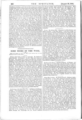
(Under this heading ice tiotice such Books of the week as have not been wsorood for reriew in other forme.] Military Sketch Map of Relief of Ladysmith. By Captain H. Delme-Radcliffe. (E. Stanford. 10s. 6d.)—This sketch map is in two parts. One exhibits the country from Chieveley (the start- ing-point of Sir Redvers Buller's advance) in the south to Thorn- hill Ridge, Surprise Hill, Bell's Hill, and Pepworth Hill (positions of the Boer investing force) on the north, a distance of about twenty miles, Ladysmith itself being about sixteen miles from Chieveley. All the natural and artificial features of the country are given,—rivers, hills, /Lc., with railways, roads, &c. Besides these there are " inset " pictures of Surprise Hill, Gun's Hill, and Lombard's Kop, and part of the Boer position at Colenso. The key map exhibits the same country with the Boer lines round Ladysmith, the position occupied by the Boers when they en- deavoured to resist the British advance, and the lines of advance made from Chieveley by the various divisions of the relieving force. A letterpress summary is furnished of the actions fought by this force from February 14th to March 1st. The casualties amounted to about two thousand, or somewhere between seventy and eighty per thousand. Tho Boers had, it is supposed, about thirty thousand in the lines investing Ladysmith, and twelve thousand in the positions from which they opposed General Buller's advance. The totals of both sides were, it will be seen, fairly equal, the force that held Ladysmith being included. The maps are admirably executed and most instructive. Few military incidents in history have been better represented than this.