


NATURAL ADVANTAGES OF THE COUNTRY.
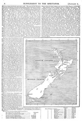
THE New Zealand group consists of three principal islands. The North Island contains, according to estimate, 31,174,400 acres ; the Middle Island, 46,126,080; and the South or Stewart's Island, 1,152,000. A more distinct notion of their size may be conveyed to the reader by reminding him, that the North Island is only about a thirty-second part less than England exclusive of Wales and Scotland ; that the Middle Island is about one-ninth part less than England and Scotland ; and that the three islands together contain 78,432,480, or about 100,000 acres more than the whore of Great Britain and Ireland with all the little islands that surround them added.
The 78,000,000 acres in the British Islands are inhabited by 27,000,000 of civilized men, women, and children. The 78,000,000 acres in the New Zealand Islands are inhabited by about 100,000 savages and 14,000 European settlers. England gives less than three acres to every inhabitant ; New Zealand, more than seven hundred acres to each.
From the Southern extremity of Stewart's Island to between East Cape and the estuary of the Thames in the North Island, New Zealand extends 1,000 miles from North-west to South-east, having a breadth of about 150 miles at the Southern extremity, about 210 miles at the Northern, and narrowing to about 100 mid-way between the extremities. North of the estuary of the Thames, a peninsula runs out to the North-west ; 200 miles long and nowhere 50 miles broad. What with deep bays, estuaries, and straits intersecting the islands, no part of them is more than a hundred miles distant from the sea. Much of this is high land. The whole of the Northern Island South of the estuary of the Thames, with the exception of the plains to the South of Auckland, and the triangular piece of land projecting into the sea at Mount Egmont, is a high table-land. The crest of this table-land is farmed by volcanic mountain-ranges, extending nearly North and South from the Tararua range North of Wellington, to Rangitoto, SW. of Lake Taupo ; some of whose summits ascend into the region of perpetual snow, but by far the greater part of its surface consists of high undulating plains yielding excellent pasturage. To these plains there is easy access from the North by the vallies of the Waipa, Waikato, Piako, and Thames ; from the South, by the vallies of the Wanganui, Manawata Hutt, and Wairarapa; and from the East by a number of smaller valliee, which open into Hawke Bay and the Bay of Plenty. The Middle Island is less known. With the exception of some isolated points towards the Southern extremity, (Otago, Molyneux Harbour, Port Macquarie, and Dusky Bay,) we are acquainted only with the Northern declivity of the mountain-mass which rises between Cape Foulwind on the West side of the island and Cape Campbell on the East ; with the base of this mass from Cape Campbell Southward to Lookers-on----about eighty miles ; and the rich grassy plains which from Lookers-on extend far into the interior for a distance of two hundred miles along the coast, having Banks's Peninsula, with its bluff coast and excellent harbours, projecting into the sea about mid-way. Along the line between Cape Campbell and Cape Foulwind are a number of summits which rise into the region of perpetual snow ; and parallel ranges of snow-clad summits extend from this line as far South as the parallel of Nelson, separating the valley drained by the Waimea and the Motueka to the West from the vallies opening into Massacre Bay, and to the East from the valley of the Watrau. Nearly South-west of Nelson a river rises, the upper part only of which has been explored, but which there can be no doubt enters the sea at a wide, level, and apparently fertile opening immediately to the North of Cape Foulwind. The shores of Tasman's Gulf and Cloudy Bay present wide extents of madfiats, which promise well for dairy and pasturage husbandry the extent of arable land in the bottoms of the vallies stretching inland from these bays is limited ; the bottoms have a considerable slope, and rise to the level of the high table-land on which the snowy summits rest ; this upland and the sides of the vallies are well adapted for sheep-feeding. Numerous passes connecting these vallies have already been discovered: and the numerous deep sounds, which intersect the Northern extremity of the Middle Island, facilitate communication in this mountainous and seemingly difficult country. The South-eastern declivity of this mountain-mass is yet unexplored, and its extent unknown; but the wide grassy plains at its base are channelled to the North of Banks's Peninsula by rivers navigable for vessels of small draught to a considerable distance inland ; and South of Banks's Peninsula a large fresh-water lagoon indicates the existence of similar means of communication in the interior. The agricultural produce of that extensive district can thus be easily transported to the excellent harbours of Banks's Peninsula, which are within an easy distance of Port Nicholson and Port Underwood in Cloudy Bay. The facility of access to all parts of the South Island and the Northern Peninsula are obvious from their limited extent, inconsiderable elevation, and the number of bays and estuaries which intersect them.
Although all parts of these islands are within a short distance of the sea, and easily accessible, the question whether they are worth going to remains to be answered. The soil is fertile in the bottoms of the Tallies from decayed vegetable matter ; and even the soil of the uplands, though less promising in appearance, becomes fertile with Judicious management in the course of a couple of years. The temperature of the atmosphere approaches nearly to that of the South of France, and is rendered bracing to the human frame by frequent cool breezes from the swowy mountains, and favourable to the growth of vegetables from the moisture brought by the seabreezes. All the cereals and garden-vegetables of Europe flourish and yield abundantly. Cattle fatten and increase rapidly. The wools of an experimental shipment from New Zealanst brought higher prices in an unwashed state than washed Australian wools of a similar quality. Bees have been introduced, and thrive well. The spars of the Northern Peninsula are famous ; excellent shipbuilding-timber and a great number and variety of beautiful woods for the cabinetmaker are found all over the islands. The native flax is a weed ; and though perhaps inferior for some purposes to hemp and European flax, is superior for fishing-lines, and with proper treatment capable of being wrought up into elegant fabrics. Coal is found in great abundance its Massacre Bay: indeed, the substratum of the neck of land terminating at Cape Farewell appears almost a solid mass of coal. The seam on the surface (which alone has yet been worked) has not been found to answer for the forge, but it is of first-rate quality for raising steam. Copper and other ores have been found in considerable quantity on the estuary of the Thames; and the extensive volcanic region round Lakes Taupo and Rotorua promises to yield abundance of salts for the chemist. Some experimental shipments of sulphur from the volcanic islands in the Bay of Plenty have been made. The whale-fishery is already prosecuted with success from New Zealand ; and the shores swarm with fish, which might be made a profitable article of export to China, the Philippines, the Moluccas, Java, and Singapore.
The relative position of a country to others is an important element of its natural capabilities. The New Zealand Islands are situated in the latitude of New South Wales and Van Dieman's Land. The average voyage from the Islands to Sydney (a constant market for grain) is about fourteen days ; the return voyage ten days. The voyage from Wellington to Valparaiso (where the New Zealand woods are in request) has been done in thirty days. The average voyage to Manilla is six weeks ; to China (Canton) two months ; and Bombay has been reached from Wellington in two months. New Zealand is admirably situated for carrying on commerce with countries so rich in tropical pro
duce as those we have named, and with the whole Eastern Archipelago.
The position of New Zealand gives it political importance. The continent of Asia is connected with the continent of Australia by a chain of islands—Formosa, the Philippines, Borneo, the Moluccar„ and New Guinea—so large, and separated by such narrow straits, as to lend to that region a semi-continental character. From the East coast of the Philippines to Pitcairn's Island, a distance of nearly 8,000 miles, a belt of small thickly-clustering islands with an average breadth of 1,400 miles, extends from North-west to South-east. Most of these islands are rich in tropical productions. European settlers are to be found in many islands of this archipelago. A desultory but not unimportant trade is carried on with them in European vessels. European Missionaries have been settled for many years in Otaheite and some other islands of this belt ; and an imperfect glimmering knowledge of European civilization has been carried even beyond the sphere of their immediate influence by Native Missionaries trained by them, and by the American Missionaries in the Sandwich Islands, which are rather to the North of the belt of thickly-sown islands. Runaway sailors and convicts have also found a shelter in some of the less known islands. All these elements are producing a fermentation among the population of this archipelago, at the very time that European intercourse with them is becoming more regular and frequent. Some means of exercising a maritime police over them is highly desirable. Any one who looks at the map of the Pacific and sees the relative position of New Zealand to these islands—mid-way between the two extremities of the belt, at a distance of less than twenty degrees from its Southern edge—must feel at once what an irresistible control this group, if well-peopled by moral and intelligent European colonists, could exercise, where at present anarchy reigns.
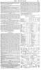
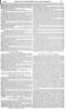
This Map of the Islands desigtmted by the general name of New Zealatul is more correct -ut its outline than any that has been published; but the scale is unavoidably so small, to lit our column, that it was found impossible to indicate mountain-ranges iutelligihly.
In the North Island-North of Auckland, except in the ease of isolated peaks. the
bills rarely rise above 300 feet. N. of Hokianga is an isolated mountain called
Mount Camel. about 2000. feet high. The Tarerun range. immediately N. of Wellington, extends to the Mattawatu. The courses of he affluent which enters that riser at its SW. bend, and of the listamahenga. the river which flows towards Palliser Bay. indicate the Eastern base of the Tararua range. At its S. extremity this range touches the sea ; Northwards a plain of some breadth intervenes. Snow rests a good part of the year on its higher summits. North of the chasm through 'which the Manawatu flows, the rauge iscalled Bauswahine. It °Cowls N. on the W. side of Lake Taupe. interrupted by a broad pass, through which the Waikato flows N. to the lake, and a smaller river S. to Coak's Strait. The highest peaks are Tongerire, (nearly S. of the SW. corner of the lake.) Ruapeltn, (S. of Tonguriro,) and Bangitoto. (equidistant from New Plymouth. Kawia, and the NW. corner of Lake Taupo). The two former are 9.000 or 10,000 feet above the sea. N. of Rangitoto a low range extends to near the month of the Waikato, between the -sea and the Waitta—the W. branch of that -liver. The land between the Ruawaltine .range attd the W. sea is low, except the isolated Mound Egmont, near the Cape of that -name, uhtirhi is about 9,000 feet high, and the rugged highlands about the Wanganui, which reach to within 20 miles of the sea. East of the Reawaltine range are high undulding plains. North of the Rotorua lakes, between the Thames and the sra, a narrow prolongn
than of this bight I reaches the S. headland of the Frith of the Thames. A similar projection, but of less height and interrupted by -passes. runs S. to Cape Palliser.
In the South IslandThe space between -Cape Foulwind. Cape Campbell. anti Cook's Straits, is occupied by a mountain-masa. From Cape Campbell the mountains rise immediately from the sea as far S. as Looker's-on ; thence they strike inland in a SW. direc. Sion, leaving a wide plaits between them and the coast. At Port Otako on the E. anti Dasky Bay on the W. coast, the country is mountainous. Whether an unbroken chain of mountains consents the high land at both
ends of' the island, is uncertnitt. Captaill Cook, in running down the W. coast, saw mountain-peaks at shun t intervals rising abase the mists which wrapt the shore. The site and dimensions of the two lakes laid down ter the map, inland from Port Otako, are very problematical.
Stetvart's Island is low. Along the E. coast there is a regular bank of soundings, and good holding-ground for anchorage. The Bay of Islands, the Frith of the Thames. The inlets of Banks's Peninsula. Port °take, Port Underwood. and Port Nicholson. (especially the last.) are excellent harbours. There .ase accumulations of water. or fresh water la. goons. in Palliser Bay (W. of Cape Palliser) and along the beach S. of Bauks's Peninsula, which only cum monicate with the sea at certain Seasons. Os the W. side of the Middle Island soundings are only got close in with the bold coast. On theW. side of the North Island there are only barbarbours. There is good anchorage in Tasman's Gulf—the great indentation between D'Urville's Island and the spit et land running W. from Cape Farewell.
•
The small island in Cook's Straits (near the head of the letter K in " Cook " on the map) is Kevin. the residence of Raupereha. Immediately in front of Poriruathe indentation near the W in •• Wellington "—is the island Marta, the residence of Bangihretta.
The superficial contents of these islands are as follows—
The whole length of the Islauds 1,200 miles The length from Auckland to the N. point 200
The length from Auckland to the S. point 1.000
Number of acres in North Island 31.174 4e0
Number of acres in Middle Island 46,196.080 Number of ens in stewed', Island 1.152.000 Number N. of 3El1t degree of South latitude.. 7,942,400
Distance. Bearing.
From Wellingtm to Sydney 1,570 W. N. W.
, .. Hobart Town 1.610 W. by S.
„ Metbourne 1.680 W. by N. Adelaide 2,170 W . by N. King George's Souud 3,290 Ws by N. Valparaiso 6.440 . N. by E. °wit:tile 2,800 N. E.
Satelaich Islands .. 4,760 N. N. E.
MAII illa 5,40 N. W.
Hong-kong 5,960 N. W •• .. Itateria 5460 W. N. W.
10 I/
Singapore 4810 . NW.