


Bird’s-eye views
Andrew Lambirth
The Past from Above: through the lens of Georg Gerster British Museum, until 11 February 2007 London: A Life in Maps
British Library, until 4 March 2007
Georg Gerster (born 1928) is a Swiss photographer who specialises in shooting from above. For more than 40 years he has been taking aerial photographs, and has flown over 111 countries. Concentrating on archaeological and heritage sites, Gerster has made what might accurately be called an ‘overview’ that has greatly enhanced our archaeological understanding. His pictures have been reproduced in National Geographic and used on Swissair posters and calendars. He is what you might call a popular photographer, and a very fine one. The current exhibition of his work at the British Museum presents his photographs in a very low-key way: blown-up and unframed, they resemble illustrations from a magazine or subsidiary information panels rather than exhibits. (The triumph of content over style.) As if in recognition of this, the display has been plumped out by a selection of ‘real’ exhibits, ancient or modern artefacts from the sites depicted. It’s as if these, not the photographs, have the Museum’s actual seal of approval. Photographs as art objects, properly framed and displayed as valuable in their own right, somehow don’t seem acceptable. Yet the show is trumpeted as ‘the first major photographic exhibition at the British Museum’. Some discrepancy, surely?
So this is less a tribute to Georg Gerster than a celebration of the sites depicted, as seen from the air. It seems a bit hard on the photographer, but in others ways such an ego-light exhibition is rather refreshing. It begins in Africa, with the Olduvai Gorge in Tanzania, the cradle of humankind. Next is a powerful shot of the massive drystone walled enclosures of Great Zimbabwe, legendary capital of the Queen of Sheba. A beautifully incised soapstone figure with tapering trunk is displayed in a case beside it, reminding us we’re in a museum. The cruciform church of Beta Giyorgis, Lalibela, Ethiopia, carved out of the rock is another dramatic image, with nearby a Roman field system at the Kharga Oasis in Egypt, the crescent sand dunes threatening an earlier man-made geometry. This is one of the leitmotifs of the exhibition: natural phenomena juxtaposed with man-made, and the interplay between the two. Appropriately, a mummy portrait is shown in the case next to the oasis.
Moving swiftly through into Asia, we see a truly amazing pattern of sand dunes coming up against a fort at Qalat-i Gird in Iran. It’s a striking photograph, which looks more like peeling bark or paint bubbling on a door than a desert. The way the earth is raked and combed in agriculture or stacked in defence emerges so clearly from above that you feel humanity must have always been destined to fly — if only for this perspective. A very different milieu is that of the Marsh Arabs in Iraq, reed houses on islands of silt, shared for a while in the 1950s by Wilfrid Thesiger, and since destroyed by the redirection of the Euphrates. There’s an incredibly poignant photograph of the Great Wall of China, threading its elegant but rather puny way through the mountains. The keyholeshaped wooded burial mound of Emperor Nintoku of Japan has a far greater dignity and presence.
With a certain inevitability, Australia is represented by Uluru (with a dotted dreamtime painting next to it), though the photograph is an immensely dramatic one, staggeringly lit. Thence on to the Americas, and the Nazca lines in Peru, made only to be read and understood from the air, and therefore by whom? The gods? The raised fields and platforms of Ecuador look like a lush tapestry in comparison, while the fringed and beaded Blackfoot buckskin dress is distressingly like a Hollywood prop. The photo of Moose Mountain Medicine Wheel nearby strikes an admonitory note. When this 2000-year-old site was first observed in 1895, the centre was 4.3 metres high. Now farming and souvenir-hunting have reduced it to just 60 cms. Into Europe and closer to home. Athens, Sounion, Argos, Myceneae — are these the real cradles of civilisation? Cramped into the last room, and reproduced on a surprisingly small scale, are what many have come to see, the English sites. Here are Hadrian’s Wall with a large fort attached, Stonehenge, of course, and a charming photograph of turning hay around a Bronze Age barrow in Wiltshire. Almost as an aside, the caption states: ‘On average one archaeological site has been destroyed each day since 1945, mostly by ploughing.’ The display concludes with such old favourites as the priapic Cerne Abbas Giant and the White Horse of Uffington in Oxfordshire, the oldest chalkcut hill figure in Britain, dating from 1200 BC. The final photo, the 100th, is a new one of the British Museum, secure for the moment in its Bloomsbury fastness. But how safe are any of these great treasures? We need to be endlessly aware of our heritage and our responsibility to it. This show is a timely and enjoyable reminder of such duties.
At the British Library is a complementary exhibition, a history of London through its maps. There were virtually no maps made before 1400, and the first modern maps date from after the Great Fire of 1666, but there are 16th-century items on show here, including Anthonis van der Wyngaerde’s bird’s-eye view of Henry VIII’s London. (Don’t get too excited: although this looks a lovely drawing, it’s only a facsimile, which leaves the viewer feeling slightly cheated.) A smaller and less ambitious work depicts London in the year of the Armada (1588), done in handsome colour (all red roofs and optimistic blue for the Thames) by William Smith. The Fire changed less than had been expected. Sir Christopher Wren’s muchlauded scheme to classicise London, with piazzas and long straight avenues and vistas, was never realised. It wouldn’t have worked. As Joshua Reynolds said later with considered understatement: ‘The uniformity might have produced weariness, and a slight degree of disgust.’ Thankfully, London adhered to its mediaeval street system.
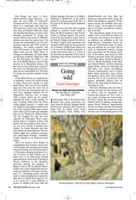
This is an extensive show. Despite its unsympathetic boxy structure, when I went a lot of people were spending their Sunday afternoons poring over such documents as a 17th-century planning permission for a row of houses on Hares Marsh, east of Brick Lane; or an 18th-century drawing with watercolour of the inside of the King’s Theatre Pantheon; or the 360-degree panorama showing the periphery of Regent’s Park in 1831 by Richard Morris. People seem to like relating their own contemporary fiefdoms to the maps of yesteryear. It’s a fascinating pursuit, and with much to study (including loose material in plan chests to handle) don’t expect to ‘do’ it in a hurry. It’s a good exhibition to browse in, whether your fancy takes the delicate drawing of the spire of St Bride’s attributed to Hawksmoor, or the earliest printed fire insurance plans from 1857, or the map of the British Empire Exhibition of 1924.
Did you know that John Nash originally planned an imitation Greek temple to house the Royal Academy in what became known as Trafalgar Square? The government of the day refused to fund it and we got Nelson’s Column instead. Now the latest thing is digital aerial panoramas (via satellites) which might put Georg Gerster out of business. Google Earth enables you to fly over all the familiar landmarks. It sounds rather better than it is. I have to say that from my experience of the current technology, Herr Gerster need fear nothing yet.